END-WET Course Book
Greetings! This course book is intended to serve as your one-stop shop for END-WET information. Both swimmers and support paddlers may find the course book to be helpful. If you still have questions after reading the course book, drop us a line! (endracing@gmail.com)
I. Race-Specific Information
II. Swim Logistics
III. Race Week Schedule
IV. Lodging
V. Support Paddler Information
VI. Spectator Information
A) Rules
The solo swim categories are described below, along with rules pertaining to inclusion in each category. There is no distinction between genders in this race; men and women are competing against one another for placing!
Non-Wetsuit Category: FINA OWS swimming guidelines apply. Athletes in this category cannot use any buoyancy aids or speed aids (no wetsuits, pull buoys, hand paddles, fins, snorkels, etc.). Rash guards, music, and dive masks are fine, however, as is any type of fabric swimsuit. Grease is also allowed.
Wetsuit Category: Wetsuits are allowed; speed aids are not.
In order to be considered an official finisher of the event, in any class, the following guidelines must be followed:
a) Racers must complete the full 36 miles under their own power, uninterrupted by stops on land. In the event that a swimmer “touches bottom” in the middle of the river, they will not be disqualified as long as they don’t use the bottom for forward progress. Exceptions will be made in the event of lightning-related issues.
b) Swimmers cannot have physical contact with their support boats or paddlers. Incidental/accidental contact won’t result in disqualification. This means swimmers can’t hang onto the boat during feeds!
c) Racers must comply with directions of race personnel regarding cutoff times (below).
Cutoff times:
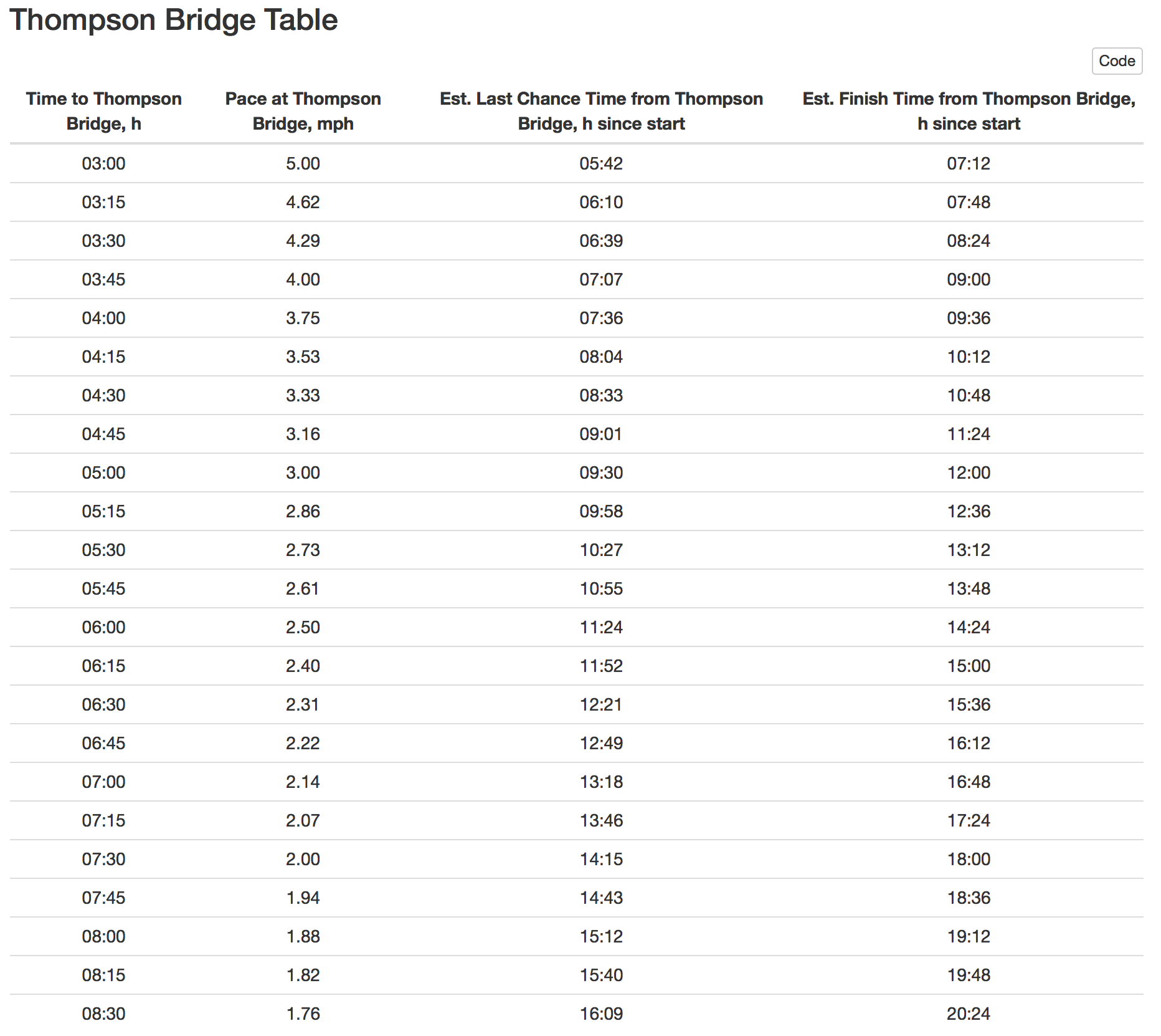
We are not allowed to be on the river after sunset. For consistency, we're calling this a 16-hour race if start is at sunrise even though it's usually a few minutes either way. There will be two locations where we will be determining average swim pace. Pace determination and cutoff time will be based on race start time and the discretion of the volunteer staff. If you're thinking of dropping, it's a bit easier (shorter walk to a vehicle) to get out at Thompson Bridge.
- Thompson Bridge (mile ~15, 21 miles to go)
- We will allow you to continue after Thompson Bridge if you are on pace to reach Last Chance by sunset.
- If race starts at sunrise, cutoff time at Thompson Bridge is 8:20 (8 hours and 20 minutes) since race start.
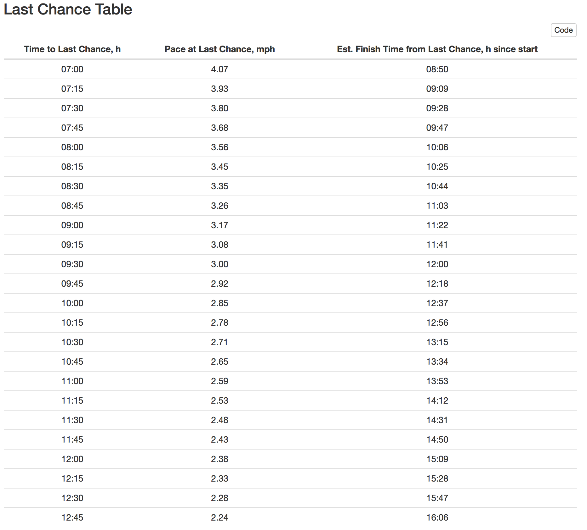
- Last Chance (Adams Drive) (mile 28.5, 7.5 miles to go)
- We will allow you to continue after Last Chance if you are on pace to reach the finish by sunset.
- If race starts at sunrise, cutoff time at Last Chance is 12:40 (12 hours and 40 minutes) since race start.
Time tables (click to enlarge) just break this down in case the race starts significantly later than sunrise:
B) River Conditions
A map of the race course is available here.
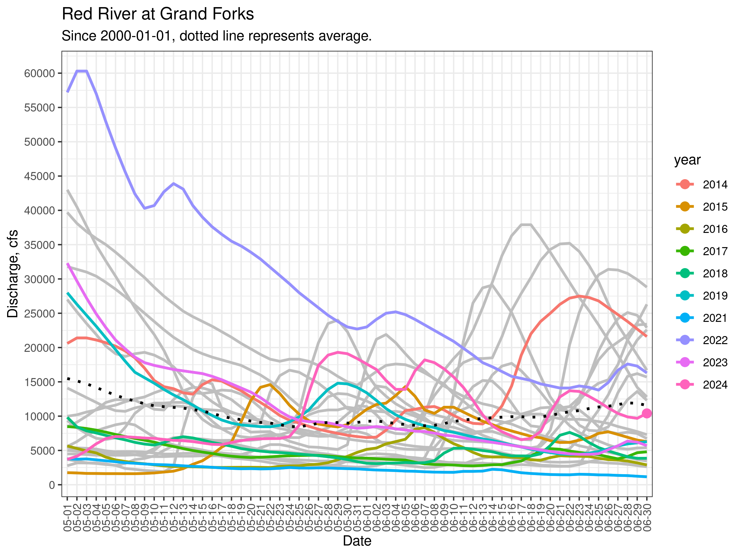
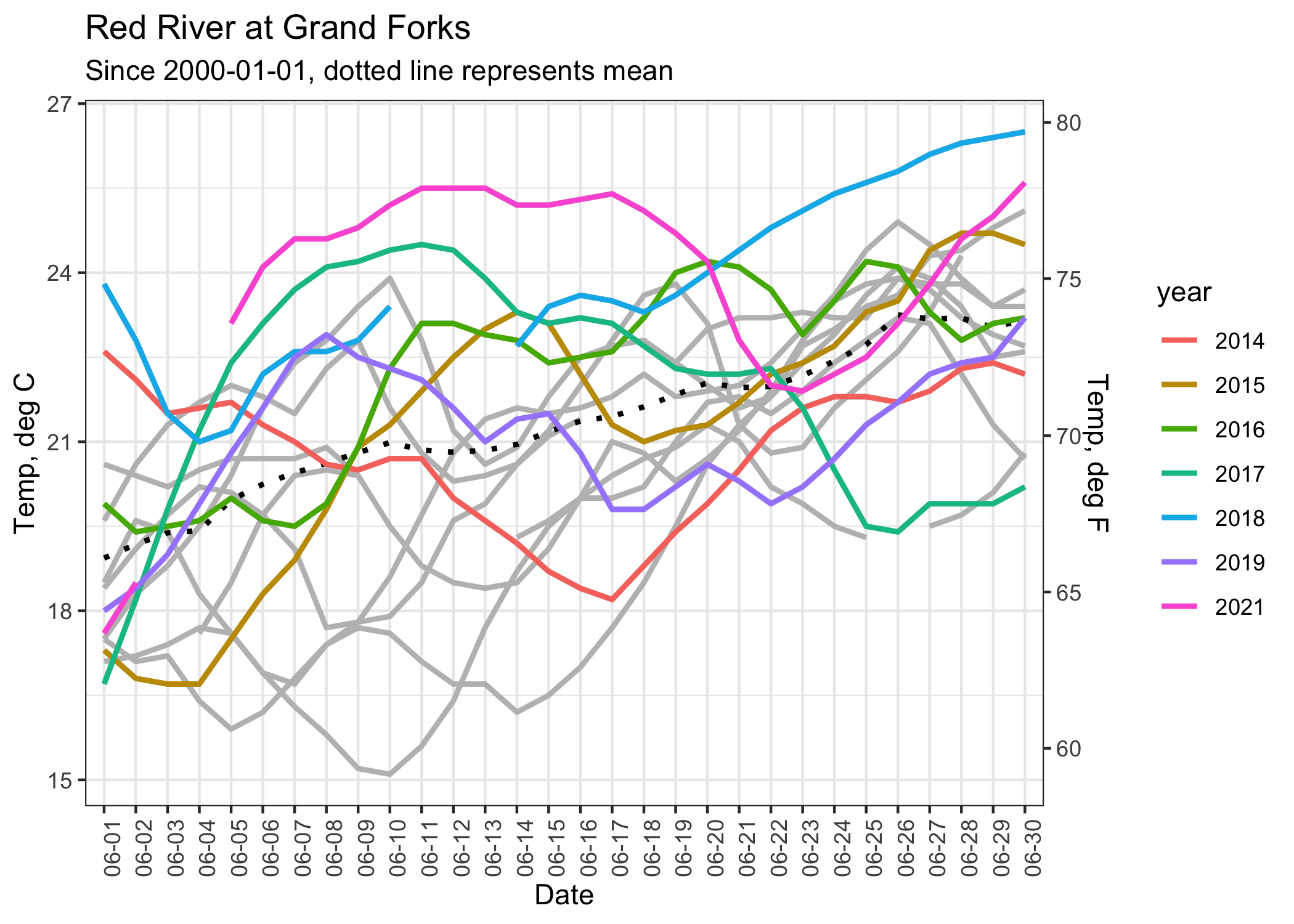
The river varies in width from about 150 feet to more than 300 feet in places. The current averages between negligent to 1 mph or so, depending on water levels. In 2012, the river was at record low levels and most swimmers touched bottom at least once. In 2013, flows were up and times were faster and no one touched bottom. In 2021, well, yeah it was like 2012. Current river conditions (including temperature) can be found here: http://waterdata.usgs.gov/nd/nwis/uv?site_no=05082500 (live gage height, discharge and temperature plots below).
Race permits are valid when the river is below 30 ft gage height (2022).
Precipitation forecast in next week (inches, live):
Here is a plot showing river discharge (amount of water flowing at Grand Forks, cubic feet per second) in May and June. This plot is updated daily at 5 AM central time.
The visibility within the river is approximately 8 inches because of the high turbidity. The water itself is clean and safe to swim in, however. The banks are lined with majestic old cottonwoods, many sporting eagles’ nests. It's awesome!
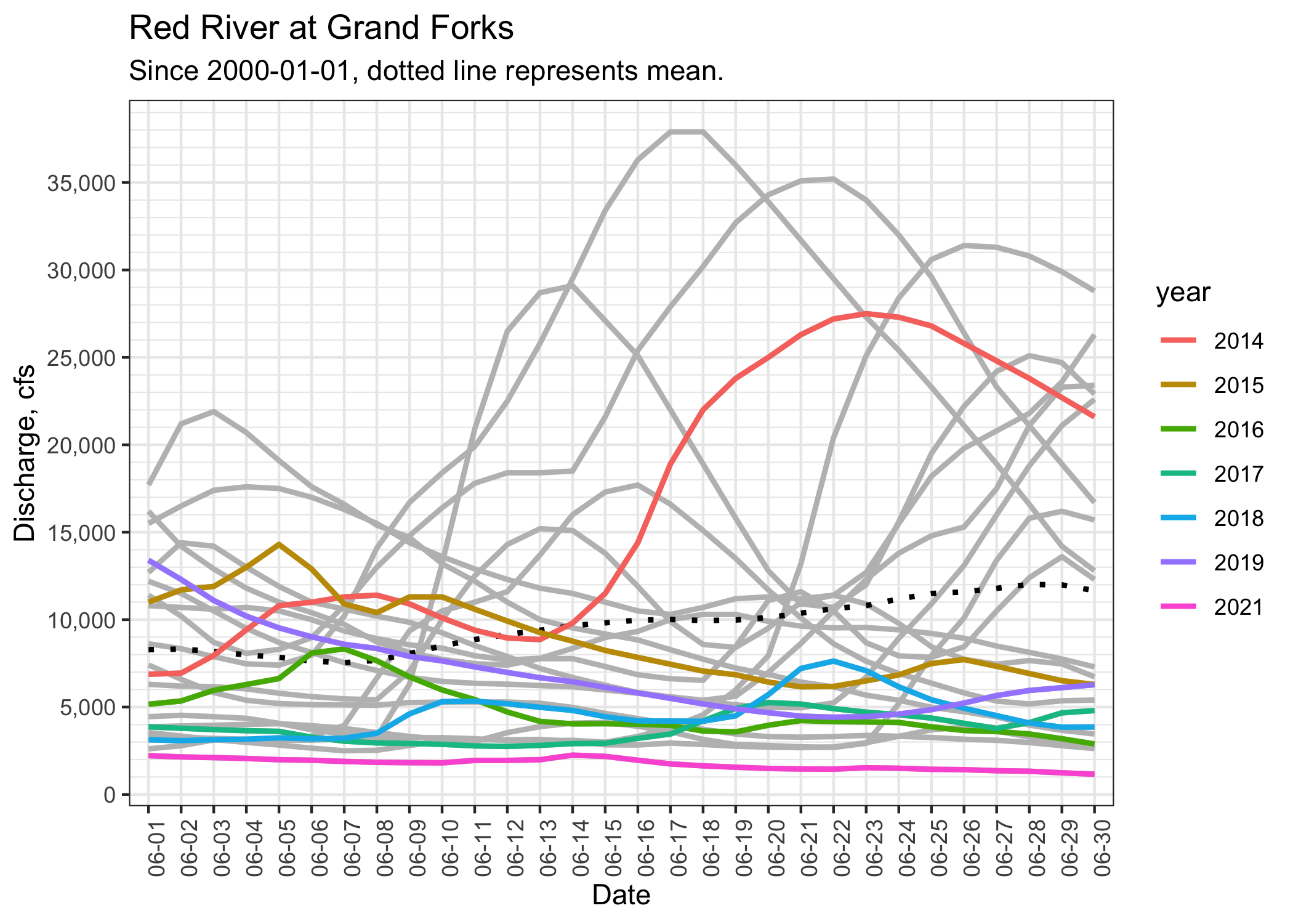
Here are some plots showing the river discharge (amount of water flowing at Grand Forks, cubic feet per second) and temperature over the month of June over the last 20 years. 36-mile race years are highlighted.
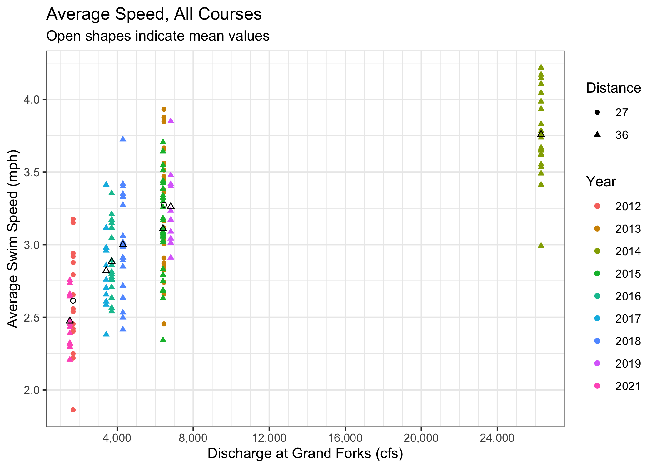
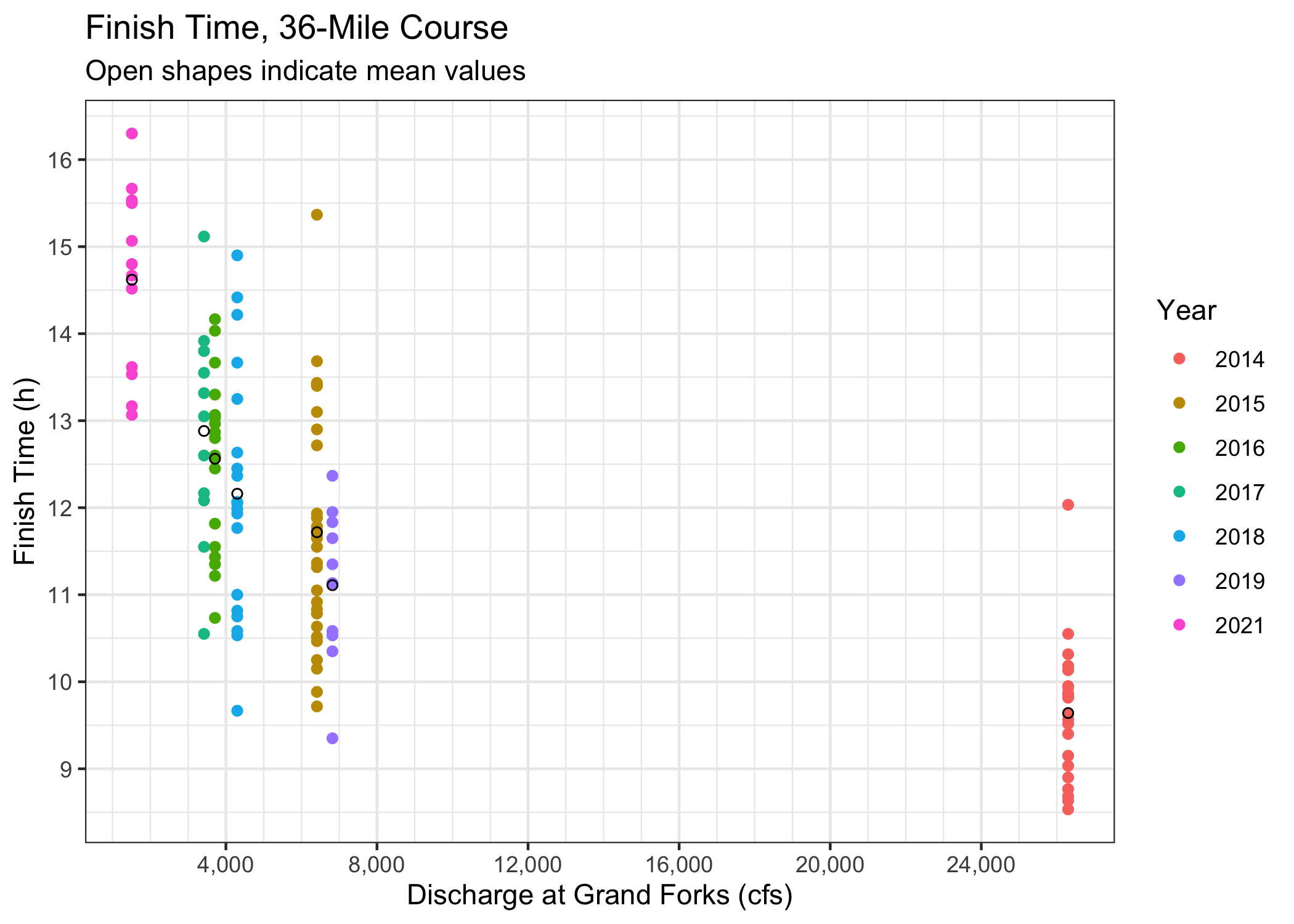
Here are some plots derived from the race results. The x-axis on both is river discharge. Hopefully this will give you an idea of potential speed and finish times.
This plot includes results from both the 27-mile and 36-mile courses, with attempted normalization to speed rather than finish time.
This plot shows how 36-mile finish times are affected by river discharge. The average (mean) finish time is shown as an open circle in the middle of each stack of finish times for a given year. There is a general curve that could be traced through most of the average times, but the 2019 finishers seem to have been (as a whole) generally faster than such a line would indicate.
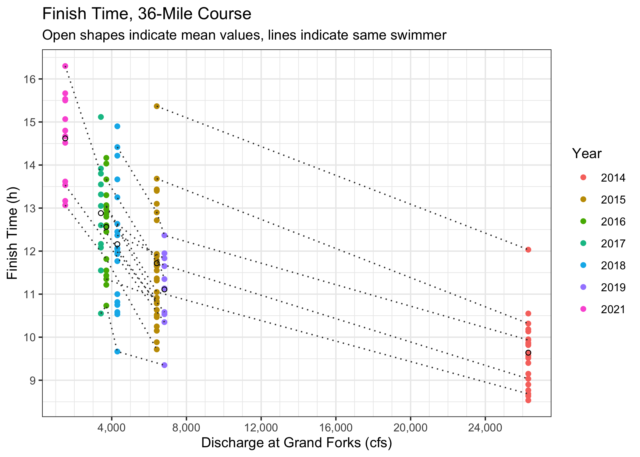
This is the same as the previous plot, but points representing swimmers who have raced multiple years are shown by dashed lines.
Logistically, supporting a swim this long is a challenge. Multiply that by 30 and add difficulty because the river is so inaccessible during most of its length, and well, you get the picture! Below are some logistical details to keep in mind. Many of our previous racers are on the Marathon Swimmers Forum (search for "END-WET") and are happy to share experiences.
A) Nutrition
Swimmers: remember that this is the longest race in North America and much of the river is essentially inaccessible from the shore. Please think carefully about what you need to be successful at the race and don’t pack what you don’t need. It’s important that you have enough, but be aware that some support boats might have a limited amount of room.
B) Resupply
Nutrition should be split roughly in half, as there is a resupply point at mile 15. The resupply items should be in mesh bags (or something similar) that can be easily handed to your support boater from the shore, and must be clearly marked with your full name on them. Support boats will be able to hand off trash/empty bottles at the resupply point, but please note that anything left here should be considered abandoned. Any support paddler wanting to pick up their own items at the resupply point should add them to their swimmer’s bag. All resupply bags will be transported to the resupply point by race volunteers.
C) Social Media Updates
For those with loved ones, friends, and fans following along, we plan to offer live updates during the race. We are using track.rs for livetracking. Racers will be using a mix of mobile phones and satellite trackers in support boats. This is an opt-in system, so we can't guarantee that the location of every racer will be shown. The live map will be available at https://track.rs/endwet.
The river will be marked on river left at every mile, starting at 1 and counting to 36. Please use hashtag #ENDWET if you are posting about the race. We will try to share updates throughout the day but cannot guarantee anything--keeping all the racers safe and supported is more important than posting on social media.
D) Nature Calls
It’s a long race and bathroom breaks are inevitable. Support paddlers: be aware there aren’t any enclosed bathrooms along the race course, so you’ll need to find a good place along the river bank to relieve yourself. If you end up needing to go to shore for a pit stop, make sure you discuss how you’re going to communicate this to your swimmer. Swimmers: please be gracious and understand this is unavoidable.
E) Safety
We will have an EMT in a boat on the water, but this boat will be there for medical emergencies only (not to supply food, water, Advil, etc.). In the event that a swimmer can’t continue, the best case scenario is to pull out at a manned checkpoint (see above). If this is not possible, then it’s up to the swimmer and support paddler to determine the best course of action. It’s advised that support paddlers keep their phones waterproofed in case of emergency.
There will be few or no mile markers on the river itself this year. However, there are a few ways to know where you are, either to know how much farther you have to go or to communicate your location.
- Print out a paper map of the course and navigate by counting bends. Doesn't require device or data.
- Use a GPS watch/device or phone app to track distance from the start. Many apps include a notification each mile. Doesn't require data to track distance. Reducing the update interval (if possible) will reduce battery usage.
- Download this GPX file of the mile markers and load it into a "GPX viewer" (or similarly named) phone app. Your location will be shown relative to the mile markers, even without data.
- Use your phone to access the live map at https://track.rs/endwet. If you are using the Traccar client (set up before race start), your position will be shown as well as everyone else's. Probably uses the most data, depending on the basemap selected.
- Ask another swimmer or paddler where you are.
- Ask the safety boat where you are.
Some key locations:
- Thompson Bridge, 15 miles done, 21 to go
- Grand Forks Country Club (river and footbridge river left), 27 miles done, 9 to go
- Last Chance checkpoint, 28.5 miles done, 7.5 to go
- South Pedestrian Bridge, 32.5 miles done, 3.5 to go
- Lincoln Drive Park boat launch, 33 miles done, 3 to go
- Point Bridge, 35 miles done, 1 to go
- "Mt. Haga" (bridge pillar in river), ~250 m to go, exit river left
F) Weather
The race will go on even if it’s raining. In the event of severe thunderstorms and lightning in the vicinity of your location, swimmers who opt to ‘wait out’ the storm on shore will not be disqualified. If the forecast is for a day full of severe storms, we will make a call as to postponement/rescheduling prior to race start.
Monday
A pre-race email will be sent to all racers and support paddlers at the beginning of race week. This email will include a link to the course book for reminders, a few more finalized details, and any changes that have been made to the race (if applicable).
Friday
Race Check-in and Guest Speaker. Racers and support paddlers should plan to meet at St. Paul's Episcopal Church (319 S 5th St, Grand Forks, ND 58201) to check in between 5:30 – 6:00pm. This location is different from previous years. We will have a race information meeting at 6:15 pm and will give racers a chance to go over plans for race day, mingle, and meet with your support paddler (if not bringing your own). Pizza and refreshments will be provided.
The guest swimmer talk is scheduled for 7:00 PM on Friday after the race meeting, but you should all be there already anyway. We will probably start early if we run out of Q&A before 7:00.
Support Boat Drop. Support boaters using their own boats will either need to drop their boats and gear at the start on Friday night or arrive early to the race start Saturday morning. Support boaters using an ENDracing boat will have their boat transported to the race start by a volunteer on Friday night. A volunteer will camp at the park to watch the boats on Friday night.
Saturday (Race Day!)
Racers are on their own for transportation to the start of the race. This worked well in 2021. Volunteers will be able to transport vehicles back to the finish line after the start. Please leave keys with myself or another "official" looking person at the race start.
Racers and paddlers should leave post-race clothes at a designated drop point at the start before the race. We will also be collecting resupply bags at this point. These will be dropped partway through the race (mile 15/Thompson Bridge).
Race Start. Race start will be 5:28 AM in 2022. (This varies by year according to river conditions.)
Race start is at Belmont Park, Buxton, ND. From Climax, MN, drive west across the river (Hwy 220 to 7), take the first right (north) (172nd Ave NE), and turn right (east) after the church. Follow the park road around to the boat ramp.
Post Race. There will be "recovery food" (chips, cookies, Coke etc ) at the finish line. There will also be showers available at the Red River Recreation Area campground, just ¼ mile from the finish line. After you’re clean and dry, head over to the Blue Moose Bar and Grill for a free meal and beverage.
Sunday
No activities are scheduled for Sunday, but many people like to get together for brunch/lunch before leaving town.
For a complete list of hotels, please check out our friends at Visit Grand Forks.
There are some Airbnb rentals in town. Save $40 on your first Airbnb trip.
Wherever you stay, feel free to email us after the race and give hotel feedback so we can share.
V. SUPPORT PADDLER INFORMATION
Our swimmers have a monumental task…swimming 36 miles! Support paddlers play an instrumental role in swimmers making it to the finish line! Here’s what support paddling usually entails…
- Support paddling is an all-day commitment. Race start is 5:30 am and most swimmers are finished before 8:00 pm.
- Since you’ll be paddling and sitting in a boat all day, being in good/decent physical condition is helpful.
- Feeling comfortable on the water and in a canoe or kayak is important. Having paddling experience is a plus, but is not required. Swimmers will be going at a slow pace and stopping to eat/drink periodically, so being a fast paddler is not necessary.
- Support paddlers also assist swimmers at their designated food/drink stops. Swimmers will be bringing their own food and drinks that will be kept in your boat.
- To help ensure swimmers’ safety, we will be asking support boats to carry a phone or satellite tracker to automatically share locations with a live map (see logistics).
- Many swimmers like to be in contact with their support paddlers via email in the weeks leading up to the race. Usually, this is to discuss any special instructions or needs that the swimmer has during the race. We will provide swimmers with their support paddler’s contact information.
- Swimmers will also want to meet their support paddlers before the race. We have race check-in on Friday night before the race and this is a great opportunity for swimmers and paddlers to meet. Please plan on stopping by check-in if you’re support paddling. Check-in time and location to be announced in pre-race email.
- We pay support paddlers $160 per boat and provide a free meal and drink from the Blue Moose Bar and Grill at the finish line. After a long day on the water, you’ve earned it!
The following list of tips was submitted by Nick Zdon and covers a lot. It's worth a read.
First off, the Red River is a fairly easy paddle. There are no weeds, no rapids, and very little obstacles. It may be a long day, but it’s a long day on a great river.
Meet your swimmer beforehand and discuss and understand what they want out of the swim. Are they just looking to finish? Do they have a time goal, e.g. under 12 hours? Or are they looking for a personal record. Just get on the same page for what a successful swim for them looks like.
Figure out some basic hand signals and communication with your simmer. And determine how much communication/direction they want during the race. Some swimmers want more than others.
Basic hand signals might include:
- Eyes up for safety
- Closer to boat
- Away from boat
- Come to boat for verbal communication
Remember the goal is to let your swimmer swim. You’ll want to keep them safe, but ultimately your swimmer with want to stay in ‘the zone’ as much as possible.
Find out your swimmer's feeding/rest schedule. Some swimmers feed/rest every 30 minutes, some every 50 minutes. Also, have your swimmer show you their nutrition and detail how they’ll ask for items, and what’s expected of you when delivering nutrition. It sounds simple, but figuring it out on shore before the race is much easier than in the middle of the river.
Know how much info your swimmer will want from you during the swim, time elapsed, distance covered, avg speed, etc. Some swimmers don’t want to know any stats until halfway. Knowing what the swimmer wants to know, or doesn’t want to know, will support their mental state. For some swimmers simply knowing what time it is can be a mental distraction. Again, let them focus on swimming.
Does your swimmer want you to record the swim on a GPS app? Strava, Motionx, Gaia, etc? They might give you their phone to use, or you could use your phone and share the data with them after the race.
Remember, in order to effectively support, you must be safe, aware, and comfortable. Look out for obstacles, trees, branches, other boats etc, especially around mid-day when non-race traffic may increase.
Know what side your swimmer breathes on, and stick to that side within 10-30 yards, or whatever they prefer. Knowing what side they breathe on and how often will help when you need to give hand signals.
Pack list
- A wristwatch with a timer, it’s way easier than using your phone
- Brimmed hat, boonie style, or ball cap, etc.
- Sunscreen regardless of forecast
- Rain jacket and pants regardless of forecast
- Snacks and nutrition for yourself
- Hydration for yourself
- Padded cushion or canoe/kayak seat
- Sunglasses
- Portable phone charger/battery (Goal Zero, etc) you will need it
- Waterproof phone case
- Small flashlight
- Small chamois towel
- First aid kit (if you feel comfortable administering first aid on the river)
- Heat sheet/space blanket/emergency blanket (will be very welcome from a wet and cold swimmer if needed)
- 50 ft (minimum) of brightly colored rope/paracord
- Bathroom bottle (if you decide to go that way on the river)
- Toilet paper
- Paddle and back up paddle
- Mesh bag for loose items/trash
- Dry box for phone battery/charger, flashlight, TP, etc. basically anything you don’t want wet or muddy
- Dry bag, for rain gear, wallet, car keys, towel, etc and other clothes/bulky items
- Drop bag for the finish
- Change of pants, socks, shoes (you could be wet and muddy depending on what the river/weather is doing that day)
Things to keep in mind during the race
- Is the EMT boat up river or down river from you? Same for sheriff’s boat. Useful to know in case of emergency.
- What is your estimated finish time (36 miles in 16 hours, required minimum average speed of 2.25 mph)
- IS YOUR SWIMMER IN DANGER OF NOT FINISHING? Better to let them know earlier rather than later.
The course is relatively remote and inaccessible along much of its length. The main spectator points are at Thompson Bridge (mile 15/21 miles to go) and the last eight miles of the course along the Grand Forks Greenway.
- Printable map of the course
- Online map of the course
- Greenway map
- GPX file containing mile marker locations
There is driving access to Thompson Bridge. Some foot travel will be required for access along the Greenway; see map for parking locations.
See logistics for a link to the live map (new in 2017).

